On November 12, 1838 James Manor had two surveys made in central Texas for land he had been granted by the Republic of Texas. One grant was for 1280 acres and the other for 640 acres. Surveyed side by side, these grants gave Mr. Manor 1920 acres of land located on Gilleland's Creek.
 |
1861 Travis County map from Texas General Land Office showing James Manor's surveys marked in red
|
Shortly thereafter, James Manor built a log cabin approximately in the center of the 1280 acre survey, just a few hundred feet east of Gilleland's Creek. About 1842 a two-story house was erected in the same location. According to historical accounts the log cabin was retained to be used as the kitchen for the Manor home.
 |
| Copy of photo of James Manor's house from Austin History Center (date of photo is unknown) |
Having become a widower twice previously, 70 year old James Manor
married his third wife on April 22, 1875. She was 35 year old
Elizabeth Ann Stelfox who had also been widowed twice before her
marriage to James.
On May 20, 1879 James Manor wrote his Last Will and Testament. According to his wishes, upon his death, his homestead, including "...houses, gin house, barn, out buildings and erections, situated adjoining the town of Manor, with all the land and everything thereon..." would become the property of Elizabeth Ann for the rest of her natural life. James Manor's will can be found on The Portal to Texas History.
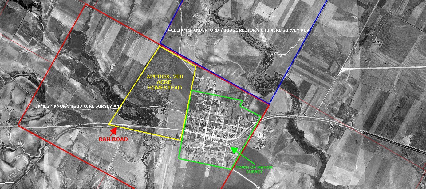
Texas law allowed married couples to claim up to 200 acres as their homestead. It seems logical that James Manor would have claimed this amount of his land as his homestead. "If, as his will states, his "house" was located on his "homestead", then the question becomes; Where was his homestead located? His will also answers that question. It states; "Beginning at one hundred feet from the center of the railroad on the Manor town survey, running direct to Judge Rector's six hundred and forty acre survey, thence running with his line westward to the corner of Barnard's and my survey. Thence southwards back to within one hundred feet of the center of the railroad. Thence running parallel with the railway line to the Manor town survey."
The "Manor town survey" was made by Theodore Kosse in either late 1871 or early 1872 when the town of Manor was established on 200 acres of land that James Manor deeded to the trustees of the Houston and Texas Central Railway Co. The north, south, east and west boundaries of the town, as well as the railroad tracks, are clearly shown on the survey.
 |
| Survey of the town of Manor made by Theodore Kosse. Originally filed with the deed to the town in Travis County Deed Records, Book V, page 796. Currently located at the Austin History Center |
If, as his will states, his "homestead" begins at the railroad tracks, adjoins the town of Manor, and extends to Judge Rector's survey, and then turns west, the "homestead" can only adjoin the town of Manor on the west side. The next logical question seems to be; Where was Judge Rector's 640 acre survey?
Texas General Land Office records show that on January 3, 1839, William Standerford (also spelled Standifer) was granted 640 acres of land in what was then Bastrop County, (now Travis County). Survey #69 for this land was made on January 15, 1839. This survey began at the northeast corner of James Manor's survey #40 and went westward along the northern line of Manor's land for its southern boundary.
On March 25, 1850, William Standifer sold his 640 acre survey #69 to Paulsen Flesher, who then sold the same 640 acres on November 4, 1852 to
Thompson (Thomson) M. Rector who, at that time, was a Judge still living in Jackson County, Alabama. According to the deed record, Flesher was required to turn over the 640 acres of land to Rector on January 1, 1853. Judge Rector moved to Travis County, TX in 1853.
 |
| 1875-1878 Travis County map showing James Manor's survey #40 in red, William Standerford / Judge Rector's survey #69 in blue and the town of Manor survey in green. From the Texas General Land Office website. |
We now know that James Manor's "homestead" adjoined the town of Manor on the west side, began at one hundred feet from the center of the railroad tracks, ran directly to Judge Rector's 640 acre survey, turned westward along the northern line of James Manor's survey #40, then turned south at "
Barnard's survey" and continued southward to within one hundred feet of the railroad tracks before turning eastward going back to the place of beginning. The only thing we don't know is where "
Barnard's survey" was located. But if we can logically assume that the homestead was 200 acres, it is not difficult to follow those directions, and the fence lines, to locate an area matching that description on aerial photographs of that area.
 |
| 1940 aerial photograph showing proposed area of James Manor's homestead |
 |
| 1940 aerial photograph showing approximate homestead land measured at 200 acres |
The 1880 U. S. Census, taken on June 23rd, lists a 24 year old white male named Marion C. Abrams living as a boarder in the James and Elizabeth Manor home.
 |
| Excerpt from the 1880 U.S. Census on familysearch.org |
James Manor died May 17, 1881 and his will was admitted for probate on July 23rd of that same year. An appraisal and inventory of the estate submitted to the court on August 23rd showed that at the time of his death, James Manor still owned over 600 acres of his original land grant surveys, not including 225 lots in the town of Manor, with his "homestead" being part of that 600 acres.
Just over nine months after James Manor's death, on March 5, 1882, 26 year old Marion C. Abrams and 41 year old Elizabeth Ann Manor were married.
 |
| Travis County Clerk Records: Marriage Record 5, page 482 |
Family histories say that Mr. and Mrs. M.C. Abrams lived in the house that James Manor built until they both died in 1941; him on January 29th at the age of 84, and her on November 3rd, at the age of 101.
In October, 1849 a group of citizens petitioned the Travis County Commissioners Court to have a road built from the north part of Austin to Brenham. It was specifically requested that the road would start at the Burditts land on Walnut Creek on the northeast side of Austin and it should include the James Manor home on Gilleland Creek. On November 19, 1849, the court appointed James Manor as “overseer” to be in charge of building that part of the road from Austin to the eastern Travis County line. When the new road was mapped and built, it ran right through the middle of James Manor’s 1280 acre land grant and directly in front of James Manor’s house.
In the following years, that road would be divided into three sections, but James Manor was always in charge of the section between Gilleland Creek eastward to the Travis County Line.
When the town of Manor was established in 1872, the 200 acres allotted for the town were surveyed and located so that the Austin to Brenham Road ran straight through the middle of the new town. |
| 1940 aerial photograph showing remains of Austin to Brenham road west of Manor |
Present day maps still show the remains of the old Austin to Brenham Road west of Manor as do recent photographs.
 |
| July 2015 Google Earth photo showing remains of Austin to Brenham road |
 |
| November 2020 closeup photo showing remains of old Austin to Brenham Road west of Manor |
As stated previously, M. C. Abrams and his wife, Elizabeth Ann (Manor) Abrams both lived in the James Manor home until they died in 1941. 1940 aerial photographs show buildings believed to be houses on both the north and south sides of the Austin to Brenham Road.
 |
| 1940 aerial photo showing buildings on both sides of old Austin to Brenham Road |
Between the years of 1898 and 1902, Travis County officials had survey's made of all the public roads in the county. These surveys, including both field notes and maps made from the surveys, were published by the Travis County Clerk's office in four volumes known as Road Books, Precincts 1 thru 4. Manor area roads are shown in the book for Precinct 1.
The map of the Austin to Brenham Road from Gilleland Creek going eastward to the town of Manor shows only M. C. Abrams property on both sides of the road.
 |
| Travis County Clerk Records: Road Book Precinct 1, page 22 from The Portal to Texas History |
The field notes of the Travis County road survey from 1898-1902 for the Austin to Brenham road starting at Gilleland Creek and going eastward into the town of Manor reads as follows;
“Thence S 68º 26 E at 129 3/5 vrs cross bridge over Gilleland Creek…”
“Thence N 71º 20 E 200 1/2 vrs passing Abrams property on both sides of the road…”
“Thence S 82º E 176 7/10 vrs passing Abrams residense on left…”
 |
| Travis County Clerk Records: Road Book, Precinct 1, page 23 |
According to these field notes, the M.C. Abrams / James Manor house appears to have been in the area marked by the yellow circle on the 1940 aerial photograph shown above.
As of today, February, 2023 there is still the remains of a house that is located in the area marked by the red circle on the 1940 aerial photograph shown above. There are also four smaller buildings still standing near the collapsed house. A fifth, smaller structure that was there previously has already been torn down due to the construction of the Gregg Manor Road extension currently underway.
 |
| Collapsed house as of November, 2020 |
 |
| Three of the five smaller buildings near the collapsed house as of November, 2020 |
A Goggle Earth photo closeup shows the locations of the collapsed house and all five smaller buildings on the south side of the old Austin to Brenham Road. Structure 2 no longer exists.
 |
| July 2015 Google Earth closeup |
According to the 1898-1902 Travis County road survey, James Manor's / M. C. Abrams' house would have been located on the other (north) side of this road. Google Earth photographs from January 2022 show the Gregg Manor Road extension construction going directly thru the area where the James Manor / M. C. Abrams house was probably located according to the 1898-1902 survey field notes.
 |
| January, 2022 Google Earth photo showing Gregg Manor Road extension construction in relation to the collapsed house and smaller buildings |
James Manor's will also states "...
at the death of my dearly beloved wife, Elizabeth Ann Manor, all of the aforesaid estate shall become the sole property of Miss Lucy Manor, and any other child or children that may be born to me, to be equally divided..."
Miss Lucy (Lucile G.) Manor was born May 6, 1876 and died January 17, 1972. Another daughter was born to James and Elizabeth Ann before his death in 1881. Elizabeth (Lizzie) Beatrice Manor was born October 20, 1879 and died August 25, 1959. The James Manor homestead became the property of Lucy and Lizzie Manor when Elizabeth Ann (Manor) Abrams died in 1941.
Lucile G. Manor married Alfred Wainright Bloor on December 4, 1901.
Elizabeth B. Manor married Carroll (Cal) Orr Elliott on June 5, 1907.
Sometime after the death of M. C. Abrams and Elizabeth Ann Abrams the James Manor homestead was sold to Dr. Ben Eppright of Austin, TX by Lucy and Lizzie Manor. A history of the Manor family written in 1953 by
Thelma Rogers Cook says;
"The old Manor Homestead is now owned by Dr. Eppright of Austin. He purchased this property from the two living daughters of James Manor: Mrs. Lucile Manor Bloor (Mrs. A.W.) and Mrs. Elizabeth Manor Elliott."
As of February, 2023, some parts of the Las Entradas development, west of Manor, still show having been previously owned by Ben Eppright, and later, by the Ben Eppright Family Trust.
The exact location of James Manor's house; that is, whether it was on the north side of the old Austin to Brenham Road on land that has already been cleared by the new road construction, or whether it was the collapsed house on the south side of the road, may, at this point, never be proven beyond any doubt and to everyone's satisfaction.
Since the entire area west of Manor between Highway 290 and Old Highway 20 is set for development by commercial and residential enterprises, it may be that at this late date the only thing that can be done is, after the area is developed, to erect a historical marker and/or some other indicators that this was James Manor's homestead. Something needs to be done to identify the area as such, but I'm not sure exactly what that would be. Ideally, the historical marker or park or whatever is done should be placed where James Manor's house was actually located but that opportunity may have already passed due to the construction of the Gregg Manor Rd extension.


Great work, but I'd heard that Col Eppright gave the land to A&M university (Foundation, maybe) and Pete Dwyer said he bought it from A&M.Where are those transactions. A&M wouldn't give them to me with a FOIA request. He gave them $4 million and has a building named after him.
ReplyDelete